What Is Los Cabos? Cabo San Lucas, San José and the Corridor
How Cabo San Lucas, the Tourist Corridor, San José del Cabo, the East Cape, and the Pacific side fit together.
In this guide
Los Cabos is not another name for Cabo San Lucas. It is both a municipality at the southern end of Baja California Sur and a visitor destination built around two cities: Cabo San Lucas and San José del Cabo. Between them, the Tourist Corridor follows the coast for about 20 miles, or 33 kilometers. That three-part model is the clearest way to understand a first trip, while the wider municipality also includes inland and Gulf of California communities. So what is Los Cabos, in practical terms? The sections below explain it.
What is Los Cabos? The two meanings
In administrative terms, Los Cabos is a municipality. San José del Cabo is its municipal seat, and the municipal tourism office also names Cabo San Lucas, Santiago, Miraflores and La Ribera as delegations. That is a broader territory than the resort strip many travelers picture when they hear “Cabo.”
In visitor information, Los Cabos is described primarily through Cabo San Lucas and San José del Cabo, connected by the Tourist Corridor. Both meanings are useful. The municipal definition explains why places beyond the two cities can still be within Los Cabos, while the tourism model explains where many accommodations, beaches and visitor services are concentrated.
The three-part visitor map
- Cabo San Lucas is the city around downtown, the marina and Land’s End.
- The Tourist Corridor is the developed coastal connection between the two cities. It is an area, not a separate town.
- San José del Cabo is the municipal seat, with a historic center and a separate coastal and hotel-zone setting.
Use the three areas to read an accommodation map. Mark the places you want to visit, then check the route from each possible base. An address between the cities can mean a very different daily journey from one beside the marina or historic center. Our guide to where to stay in Los Cabos compares the three bases in exactly that way.
Cabo San Lucas: marina, downtown, and Land’s End
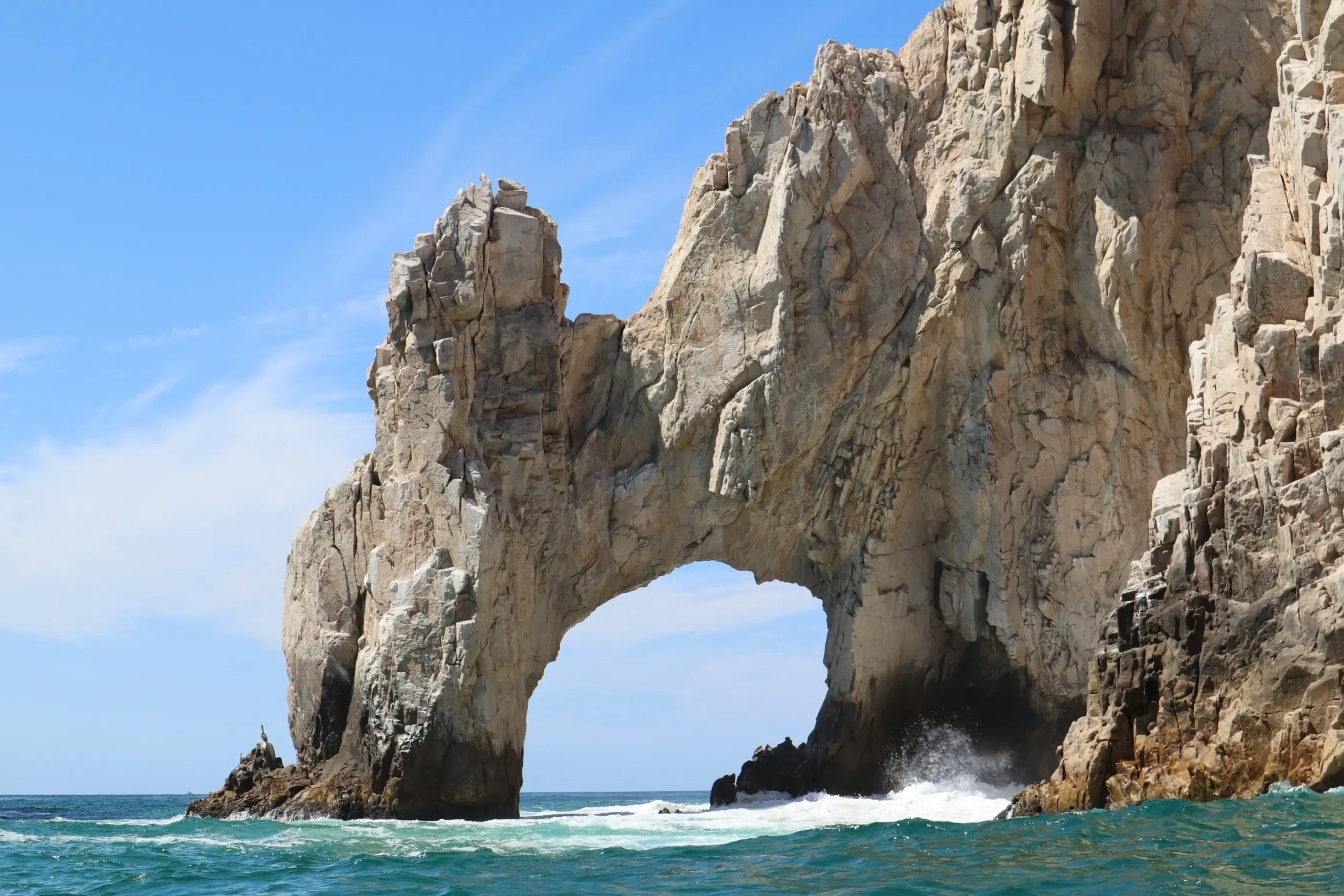
Cabo San Lucas is one city within Los Cabos. Its most recognizable geographic anchor is Land’s End, including the rock formation commonly called El Arco. The marina and the streets around downtown form another practical anchor, concentrating boats, restaurants, shops and nightlife within the central area. For the landmark itself, see Land’s End and El Arco.
Calling the whole destination “Cabo San Lucas” hides important differences. A hotel on the Corridor or an address in San José del Cabo is not in Cabo San Lucas merely because a booking page uses “Cabo” informally. Check the full place name and address before drawing conclusions about atmosphere, beach access, airport movement or what can be reached easily.
The Tourist Corridor: a coastal connection, not a town
The Tourist Corridor follows the transpeninsular road and coastline between Cabo San Lucas and San José del Cabo. Official tourism sources describe it as roughly 20 miles, or 33 kilometers, long. Resort properties, golf courses and beaches occur along it, but “the Corridor” is not a municipality, delegation or single town center.
That distinction matters when comparing addresses. Two properties can both be described as Corridor stays while occupying different points between the cities. A coastal setting does not by itself establish that a beach is suitable for swimming, that restaurants are walkable or that transport is unnecessary. Check the exact beach, pedestrian route and transport options for each property before booking. Which coves are commonly used for swimming is covered in swimmable beaches in Los Cabos.
San José del Cabo: municipal seat, historic center, and coast
San José del Cabo is the municipal seat of Los Cabos and a city distinct from Cabo San Lucas. Official visitor information centers its identity on the historic centro, including the mission, gallery district and nearby cultural streets. The estuary is another geographic landmark associated with the city. Our guide to the San José del Cabo Art Walk and historic center covers the centro in detail.
San José also needs to be read at more than one scale. The historic center, the coastal and hotel areas, and the airport side of the destination are not interchangeable points. A general “San José del Cabo” label therefore does not answer whether a particular stay is walkable to the center, directly on the coast or convenient for a planned outing. Confirm the actual address rather than relying on the city name alone.
Where the East Cape fits
East Cape is a regional travel label whose boundaries vary between maps. Plan around named places: La Ribera is a delegation of Los Cabos on the Gulf of California side, and Cabo Pulmo lies farther along that coast.
Cabo Pulmo National Park is within Los Cabos municipality, according to CONANP, Mexico’s protected-area authority. Before making the journey, confirm current road conditions, services and park rules with the accommodation or an authorized operator. See our guide to Cabo Pulmo National Park.
Todos Santos and El Pescadero are not Los Cabos towns
Todos Santos and El Pescadero are commonly discussed in trip planning from Los Cabos, but both belong to La Paz municipality. La Paz’s municipal planning system groups Todos Santos, El Pescadero and Las Playitas in a subregional development program, and its tourism site places both destinations within its own structure.
They can reasonably be described as Pacific-side destinations or possible trips from Los Cabos. They should not be called towns within Los Cabos. That administrative correction is especially important when checking local rules, public works, emergency information or official notices, because the responsible municipality changes. Our Todos Santos day-trip guide covers the journey and what to expect.
Which part of Los Cabos should you understand first?
Start with the purpose of the address rather than a broad idea of “Cabo.” If the marina, downtown streets and Land’s End are central to the plan, begin by examining Cabo San Lucas. If the stay is positioned between the cities, identify its exact point on the Tourist Corridor. If the historic center and San José setting matter, distinguish the centro from the coastal hotel areas.
For La Ribera, Cabo Pulmo or another outlying place, treat the name as its own planning problem. Confirm the municipality, road and transfer conditions, available services and any protected-area rules directly. For Todos Santos or El Pescadero, begin with the fact that the destination is in La Paz municipality even if the excursion starts from a Los Cabos hotel.
Before choosing your base
What is Los Cabos, then? A destination of distinct areas, and knowing them makes every other planning decision easier. Compare the exact accommodation address with the places you plan to visit. Check whether the beach allows swimming under current conditions, how you will get around and whether the seasonal weather suits your plans. The region name alone cannot answer those questions. Then read getting to and around Los Cabos for the transport side, and the best time to visit Los Cabos for timing.